|
|
mobile Forest Data Bank Simplifield Plans
The mBDL PU mobile application is designed to support the supervision of forests not owned by the State Treasury. It works with the existing BDL Simplified Plans (BDL PU) web application.
The mBDL PU application, thanks to its offline mode, allows users to use UPUL data in the field: valuation descriptions, economic guidelines, and cadastral plot descriptions. Users can also add new cadastral plots and register timber harvesting legality certificates (ŚLPD).
The program includes a map containing geometric data for cadastral plots, subdivisions, and divisions, as well as an OpenStreetMap base map. Features such as GPS-based localization and map orientation relative to north facilitate orientation in the field and the determination of the location of cadastral plots and forest subdivisions. Additionally, users can modify the map's appearance by enabling or disabling layer visibility, changing the base map (OpenStreetMap, orthophotomap, DTM), or adding data from external WMS and WMTS services.
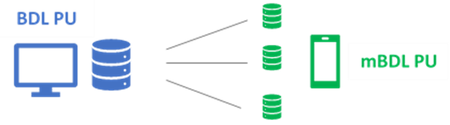
mBDL PU has the option of sending and synchronizing data with the main BDL PU database. The advantage of this solution is the ability to continuously update the BDL PU main database and maintain database consistency across all mobile devices.
Access to the application requires authorization. Users must first register in the BDL PU application. One user can configure multiple independent connections to different main databases. Multiple user profiles can be configured simultaneously on a single device.
The mBDL PU mobile application can be downloaded for Android devices.
More information is available at bdl@bdl.lasy.gov.pl.
Downloads:
The mBDL PU mobile application is currently only available in Polish.